| front |1 |2 |3 |4 |5 |6 |7 |8 |9 |10 |11 |12 |13 |14 |15 |16 |review |
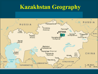 |
MAP OF
KAZAKHSTAN Location: Central Asia, northwest of China Area: total: 2,717,300 sq km land: 2,669,800 sq km water: 47,500 sq km Area--comparative: slightly less than four times the size of Texas Land boundaries: total: 12,012 km border countries: China 1,533 km, Kyrgyzstan 1,051 km, Russia 6,846 km, Turkmenistan 379 km, Uzbekistan 2,203 km note: Kazakhstan borders the Aral Sea (1,015 km) and the Caspian Sea (1,894 km) Climate: continental, cold winters and hot summers, arid and semiarid Terrain: extends from the Volga to the Altai Mountains and from the plains in western Siberia to oasis and desert in Central Asia Elevation extremes: lowest point: Vpadina Kaundy -132 m highest point: Zhengis Shingy (Pik Khan-Tengri) 6,995 m Natural resources: major deposits of petroleum, natural gas, coal, iron ore, manganese, chrome ore, nickel, cobalt, copper, molybdenum, lead, zinc, bauxite, gold, uranium Land use: arable land: 12% permanent crops: 11% permanent pastures: 57% forests and woodland: 4% other: 16% (1996 est.) Irrigated land: 22,000 sq km (1996 est.) Natural hazards: earthquakes in the south, mudslides around Almaty Environment--current issues: radioactive or toxic chemical sites associated with its former defense industries and test ranges are found throughout the country and pose health risks for humans and animals; industrial pollution is severe in some cities; because the two main rivers which flowed into the Aral Sea have been diverted for irrigation, it is drying up and leaving behind a harmful layer of chemical pesticides and natural salts; these substances are then picked up by the wind and blown into noxious dust storms; pollution in the Caspian Sea; soil pollution from overuse of agricultural chemicals and salinization from faulty irrigation practices. |