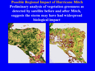
 |
Remote Sensing (RS) and Geographic Information Systems (GIS) are map-based tools
that can be used to study the distribution, dynamics, and environmental
correlates of diseases. RS is gathering digital images of the earth's surface
from airborne or satellite platforms and transforming them into maps. GIS is a
data management system that organizes and displays digital map data from RS or
other sources and facilitates the analysis of relationships between mapped
features. Statistical relationships often exist between mapped features and
diseases in natural host or human populations.
Examples include malaria and dengue fever in The Caribbean and Central
America. RS and GIS may also permit assessment of human risk from many other
pathogens. RS and GIS are most useful if disease dynamics and distributions are
clearly related to mapped environmental variables. For example, if a disease is
associated with certain vegetation types or physical characteristics (elevation,
average precipitation), RS and GIS could identify regions where risk is
relatively high.
|