| front |1 |2 |3 |4 |5 |6 |7 |8 |9 |10 |11 |12 |13 |14 |15 |16 |17 |18 |19 |20 |21 |22 |23 |24 |25 |26 |27 |28 |29 |30 |31 |32 |33 |34 |35 |36 |37 |38 |39 |40 |41 |42 |43 |44 |45 |46 |47 |48 |49 |50 |51 |review |
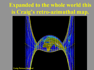 |
Craig probably did not envision the projections use for the whole world but rather only for the central region. He also suggested the map’s use for directing radio receivers towards transmitting stations. Note particularly the equidistant straight meridians, akin to a cylindrical projection. Also observe the overlapping regions. Image(s) taken from “Cartographic Map Projections of the World” CD by Axion Spatial. |