 |
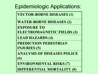
- Richards FO, Jr, Use of geographic information systems in control programs
for onchocerciasis in Guatemala. Bull Pan Am Health Organ 1993;27:52-5
- Clarke KC, Osleeb JR, Sherry JM, Meert JP, Larsson RW.The use of remote
sensing and geographic information systems in UNICEF’s dracunculiasis (
Guinea worm) erradication effort.Prev Vet Med 1991;11:229-35
- Wartemberg D, Greenberg M, Lathrop R.Identification and characterization
of populations living near high-voltage transmission lines: a pilot study.
Environ Health Perspect 1993;101:626-32
- Wartenberg D. Screening for lead exposure using a geographic information
system Environ Res 1992 Dec;59:310-7
- Braddock M, Lapidus G, Cromley E, Cromley R, Burke G, Branco L. Using a
geographic information system to understand child pedestrian injury. Am J
Public Health 1994;84:1158-61
- Barnes S, Peck Ş Mapping the future of health care: GIS applications in
Health care analysis. Geographic Information Systems 1994;4:31-3
- Beck LR, Rodriguez MH,Dister SW, Rodriguez AD, Rejmankova E, Ulloa A, et
al. Remote sensing as a landscape epidemiologic tool to identify villages at
high risk for malaria transmission Am J Trop Med Hyg 1994;51:271-80
- Bech J, Coelho C, Cecere AM. Mortalidade Diferencial no Estado do Rio
Grande do Sul. Bol OPAS 1992;43:234-36
|