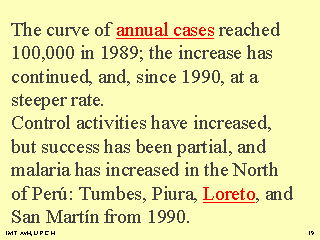
 |
The distribution of malaria depends a great deal on the physical geography of a territory.
Perú has a very accidented territory,and the SIERRA (brown in
the map) doesn't support transmission because of the altitude and cold weather.
The COAST (yellow) and Jungle (Green) do.
Malaria due to Plasmodium falciparum has increased considerably, as is seen in the series of
maps, from 1992 to 1997. Loreto shows in its districts
map that the rate of incidence for the first 3 months of 1997 also
varies, with the highest being over 10,000 cases per 100,000 inhabitants... more than 10 %!
|