Search for most updated materials ↑
 |
 |
front |1 |2 |3 |4 |5 |6 |7 |8 |9 |10 |11 |12 |13 |14 |15 |16 |17 |review |
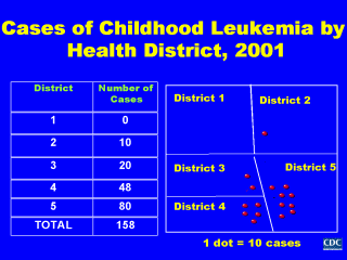 As I indicated earlier, surveillance data can also be summarized by the place in which disease or exposure occurs. This is especially useful concerning cases of communicable diseases, and health conditions associated with environmental or occupational exposures where knowing the number of cases within each district as well as the distribution of cases within and between districts is important. Presented here is our surveillance data for cases of childhood leukemia that occurred in a local health district during 2001. From our tabular data summary, we observed that the majority of cases lived in district 5, followed by districts 3 and 4. However, by mapping our surveillance data, we discovered additional information - that the majority of cases were clustered in a geographically-defined area. Notice that the cases in district 5 not only lived in the central area of the district, but also were in close proximity to the cases which lived in the far corners of districts 3 and 4. Such clustering suggested some common environmental and/or demographic risk factor for disease that required further investigation. The geographic demarcation used for mapping surveillance data may be defined as the place where cases of disease and/or exposures are first reported, where cases live or seek health care, or some other health-related characteristic. When clustering of reported diseases, exposures, behaviors, or other health-related factors are observed and they differ across different geographic areas, further investigations should be undertaken to determine if the differences are due to differences in population size or distribution, case ascertainment, health promoting or disease preventing behaviors, or other factors. |
|
|
|
front |1 |2 |3 |4 |5 |6 |7 |8 |9 |10 |11 |12 |13 |14 |15 |16 |17 |review |