Nadine McQuarrie
![]()
Home Research People Publications Photos Animations
![]()

Integrating rates of deformation
across an orogen
 One of the largest contributions to the advancement of
earth sciences in the 21st century will be documenting the rates of geologic
processes and understanding how they vary between our observational time-scales
(10s of years) and longer, geologic time scales (millions of years). In
the field of plate tectonics, the rates of interest are ones that constrain
fault motion. Historically faults have been difficult to date precisely.
Recent technical advances in thermochronometry allow us to date the time
over which rocks cool from high (450
C) to
low (60 C)
temperatures and may provide a means for dating faults. The shortcoming
with this approach is how much of that path is a result of deformational
processes and how much is purely erosional. A way to overcome this
challenge is to extract the displacement vectors from a balanced cross-section,
and use the displacement vectors to predict a range of particle path
trajectories and possible velocities. We can then test the impact these
trajectories and velocities have on mineral cooling ages by using the estimated
velocities as input for an advection-diffusion thermal model (Pecube) that predicts the resulting cooling ages.
The truly unique aspect of this research is that it allows us to
use thermochronometers as a second test to the viability of balanced
cross-sections because the cooling history recorded by a suite of
thermochronometers must match that predicted by the kinematics of a balanced
cross-section for the cross-section to be valid. Linking the kinematics
of cross sections to thermochronologic ages gives us an independent
displacement amount and age allowing us to quantitatively document rates of
deformation and changes in those rates over times scales of millions of years.
This work is in collaboration with Todd Ehlers at the University of Tuebingen.
One of the largest contributions to the advancement of
earth sciences in the 21st century will be documenting the rates of geologic
processes and understanding how they vary between our observational time-scales
(10s of years) and longer, geologic time scales (millions of years). In
the field of plate tectonics, the rates of interest are ones that constrain
fault motion. Historically faults have been difficult to date precisely.
Recent technical advances in thermochronometry allow us to date the time
over which rocks cool from high (450
C) to
low (60 C)
temperatures and may provide a means for dating faults. The shortcoming
with this approach is how much of that path is a result of deformational
processes and how much is purely erosional. A way to overcome this
challenge is to extract the displacement vectors from a balanced cross-section,
and use the displacement vectors to predict a range of particle path
trajectories and possible velocities. We can then test the impact these
trajectories and velocities have on mineral cooling ages by using the estimated
velocities as input for an advection-diffusion thermal model (Pecube) that predicts the resulting cooling ages.
The truly unique aspect of this research is that it allows us to
use thermochronometers as a second test to the viability of balanced
cross-sections because the cooling history recorded by a suite of
thermochronometers must match that predicted by the kinematics of a balanced
cross-section for the cross-section to be valid. Linking the kinematics
of cross sections to thermochronologic ages gives us an independent
displacement amount and age allowing us to quantitatively document rates of
deformation and changes in those rates over times scales of millions of years.
This work is in collaboration with Todd Ehlers at the University of Tuebingen.
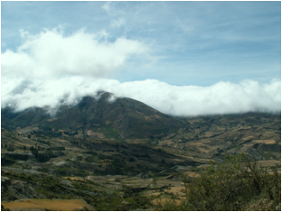
- Bolivia
In Bolivia my collaborators and I have determined
cooling ages on minerals and collected structural data that have been combined
in a kinematic model depicting how the fold-thrust belt has developed through
time (Barnes et al., 2006, Barnes et al., 2008; McQuarrie et al., 2008,
tectonics). The displacement along folds and faults was forward modeled using
the cooling ages of minerals sampled along the same transect as well as ages of
overlapping strata. Tying cooling ages to location and magnitude of shortening,
show that most of the shortening (~60%) was early (45-25 Ma) and we suggest an
~10–17 Ma pause or a dramatic deceleration in the rate of deformation and
propagation of the fold-thrust belt between 25 and ~15 or 8 Ma. The
uncertainty in the pause is based on the uncertainty in the timing of cooling
of the frontal Subandean zone. The age of
deformation in this region has been linked to multiple climatic and/ or dynamic
changes in the Central Andes emphasizing that obtaining a robust age of
deformation is critical. This is part of our ongoing research (see CAUGHT
below)
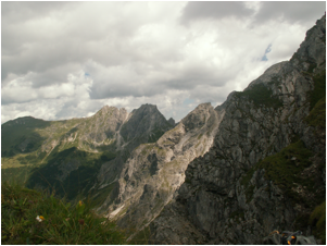
- Bhutan
Working with Tobgay Tobgay, a former graduate student and a Bhutanese native
who was the first geoscientist in his country to receive a PhD, we had
unprecedented access to the eastern Himalayan Kingdom of Bhutan. This
allowed us to 1) map the frontal, unexplored portion of the Bhutan Himalayas
and integrate new mapping with existing maps of the hinterland regions (Long et
al., 2011, Journal of Maps), 2) create balanced crustal-scale structural
cross-sections (Long et al., 2011, GSAB), and 3) obtain new mineral cooling
ages (apatite fission track, zircon U-Th/He,
40Ar/39Ar, monazite Th-Pb) that completely describe
cooling patterns from high to low temperature. These integrated cooling
curves highlight windows of fast exhumation that vary spatially and
temporally. We find that pulses of fast exhumation correlate with the
vertical motion of material, as predicted by sequentially restored cross
sections. This correlation allows us to place age constraints on
structures and their associated shortening amounts and document marked changes
in the rates of thrusting with time (Long et al., 2012, Tectonics; McQuarrie et
al., 2014 EPSL). These data show that rate and the tempo of shortening in the
Bhutan Himalayas varies with time and space, but emphasizes that the last 10
million years of shortening was markedly slower than modern rates of shortening
(GPS) or rates determined from paleoseismicity.
Similar variability is seen in the Nepalese Himalaya (Robinson and McQuarrie,
2012).
Interaction between erosion and deformation in
fold-thrust belts
 The
topographic expression of modern mountain ranges reflects the interplay between
a prior deformational history, active deformation, which is currently raising
the mountain range and erosional processes, which remove material and act to
lower the elevation. One of the main objectives of my research is to understand
the control climate (specifically variations in precipitation) and associated
erosion have on the shape and size of convergent mountain ranges as well as the
magnitude of shortening. The two mountain ranges that are ideal to test
this hypothesis are the Andes in South America and the Himalayas of India and
Asia. One of the first order changes in the morphology of the Andes Mountains
along strike is variation in width of high elevations. We evaluate the effect
of climate on topography and deformation in Bolivia where the high elevations
span a pronounced switch in hemisphere–scale Hadley precipitation regimes
at ~17 -18 S dividing the Andes into wet (15–16 S) and dry (21 S)
regions. In these regions, tectonics, basin geometry, and the deformation
style are similar, allowing us to use variations in the width of the orogen (or
changes in percent shortening) to evaluate whether the changes in width and
morphology are climate driven. Using sequentially restored, balanced cross
sections we determined that percent shortening is the same north and south
during early (45-20 Ma) deformation, indicating changes in precipitation had
very little effect on the width of the orogen. However, the later (~15 Ma to
present) deformation is narrower in the north than the south suggesting a
coupling between climate and tectonics that began between ca. 19 and 8 Ma, and
continues to 0 Ma, (McQuarrie et al., 2008, Geology; Barnes et al., 2012,
Geology).
The
topographic expression of modern mountain ranges reflects the interplay between
a prior deformational history, active deformation, which is currently raising
the mountain range and erosional processes, which remove material and act to
lower the elevation. One of the main objectives of my research is to understand
the control climate (specifically variations in precipitation) and associated
erosion have on the shape and size of convergent mountain ranges as well as the
magnitude of shortening. The two mountain ranges that are ideal to test
this hypothesis are the Andes in South America and the Himalayas of India and
Asia. One of the first order changes in the morphology of the Andes Mountains
along strike is variation in width of high elevations. We evaluate the effect
of climate on topography and deformation in Bolivia where the high elevations
span a pronounced switch in hemisphere–scale Hadley precipitation regimes
at ~17 -18 S dividing the Andes into wet (15–16 S) and dry (21 S)
regions. In these regions, tectonics, basin geometry, and the deformation
style are similar, allowing us to use variations in the width of the orogen (or
changes in percent shortening) to evaluate whether the changes in width and
morphology are climate driven. Using sequentially restored, balanced cross
sections we determined that percent shortening is the same north and south
during early (45-20 Ma) deformation, indicating changes in precipitation had
very little effect on the width of the orogen. However, the later (~15 Ma to
present) deformation is narrower in the north than the south suggesting a
coupling between climate and tectonics that began between ca. 19 and 8 Ma, and
continues to 0 Ma, (McQuarrie et al., 2008, Geology; Barnes et al., 2012,
Geology).
Like the Andes, the precipitation gradient in the
Himalayas is a natural place to test the effect of precipitation on
deformation. Our work in the Bhutan Himalayas can address the debate by
comparing shortening magnitude, percent shortening and magnitude of exhumation
to similar studies in the central and western Himalayas. Our work
indicates that both the amount of shortening (400 km in Bhutan compared to
541-667 in western Nepal) and percent shortening (56-58% compared to 72-76%) is
significantly less (Long et al., 2011 GSAB.), indicating higher modern
precipitation has not had a first-order effect on deformation.
Elevation
verses deformation
- Bolivia
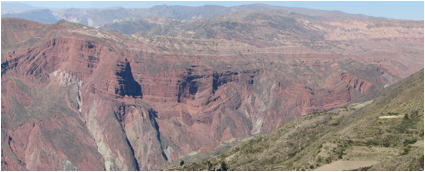 Traditionally the topographic history of mountain
ranges has been thought to mimic the deformational history. Thus as compressive forces shorten and
thicken the continental crust, the buoyancy forces
associated with a thicker lighter crust raises the surface elevation of
mountain ranges. Recent analytical
advances that capitalize on systematic changes in the ratios of stable isotopes
with elevation, particularly the ratio of O18/O16,
suggest that the deformation history of a mountain range may be decoupled in
time from the elevation history. CAUGHT:
Central Andean Uplift the Geodynamics of High Topography is a multi-institutional,
NSF-continental dynamics project designed to document the deformation,
elevation and erosional history of the central Andes mountains in South
America, specifically to evaluate whether the rise of the Andean plateau was
(1) slow-and-steady, commensurate with crustal shortening, or (2) rapid,
associated with removal of dense lower lithosphere following significant
crustal shortening. The CAUGHT team combines geophysics, structural geology,
sedimentology, stable isotope geochemistry, thermochronology,
and climate modeling to study interactions between climate, erosion,
deformation, surface uplift, lithospheric removal. Work with Andrew Leier, and Carmala Garzione shows that early (27 Ma) changes in O18/O16
isotope ratios were just as significant as later (8 Ma) changes that have been
used to infer an ~2-3 km rapid change in elevation. Taken together, the data
may infer 2 periods of uplift possibly via mantle delamination, albeit each of
a smaller magnitude than originally proposed. Our work on the age of deformation
requires that most of the shortening and thickening of the crust predated
either of these potential changes in elevation. (Leier et al., 2013, EPSL). A critical question is which uplift
pulse prompted eastward propagation of the fold-thrust belt? or did
both? Our ongoing research at Pitt
is determining the age, geometry and rate of shortening as well as
understanding the impact the 3D geometry of shortening in a curved orogen has
on the crustal thickening and elevation history.
Traditionally the topographic history of mountain
ranges has been thought to mimic the deformational history. Thus as compressive forces shorten and
thicken the continental crust, the buoyancy forces
associated with a thicker lighter crust raises the surface elevation of
mountain ranges. Recent analytical
advances that capitalize on systematic changes in the ratios of stable isotopes
with elevation, particularly the ratio of O18/O16,
suggest that the deformation history of a mountain range may be decoupled in
time from the elevation history. CAUGHT:
Central Andean Uplift the Geodynamics of High Topography is a multi-institutional,
NSF-continental dynamics project designed to document the deformation,
elevation and erosional history of the central Andes mountains in South
America, specifically to evaluate whether the rise of the Andean plateau was
(1) slow-and-steady, commensurate with crustal shortening, or (2) rapid,
associated with removal of dense lower lithosphere following significant
crustal shortening. The CAUGHT team combines geophysics, structural geology,
sedimentology, stable isotope geochemistry, thermochronology,
and climate modeling to study interactions between climate, erosion,
deformation, surface uplift, lithospheric removal. Work with Andrew Leier, and Carmala Garzione shows that early (27 Ma) changes in O18/O16
isotope ratios were just as significant as later (8 Ma) changes that have been
used to infer an ~2-3 km rapid change in elevation. Taken together, the data
may infer 2 periods of uplift possibly via mantle delamination, albeit each of
a smaller magnitude than originally proposed. Our work on the age of deformation
requires that most of the shortening and thickening of the crust predated
either of these potential changes in elevation. (Leier et al., 2013, EPSL). A critical question is which uplift
pulse prompted eastward propagation of the fold-thrust belt? or did
both? Our ongoing research at Pitt
is determining the age, geometry and rate of shortening as well as
understanding the impact the 3D geometry of shortening in a curved orogen has
on the crustal thickening and elevation history.
- Timor
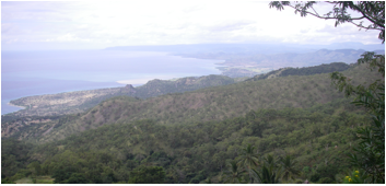 We
are also actively looking at the links between deformation, elevation and
exhumation on the island of Timor. While exhumation and surface
uplift are important parameters in constraining the development of a mountain
belt, the varied lithologies necessary to determine
both of these parameters are rarely preserved in close proximity. In East Timor arc-continent collision
since the late Miocene has uplifted a mountain range containing both deeply
exhumed metamorphic belts and piggyback deepwater synorogenic basins. These varied lithologies
are separated by a few tens of kilometers, and thus provide an opportunity to
examine the spatial patterns of differential uplift and exhumation on Timor by
comparing micropaleontology, thermochronology and
one-dimensional thermal modeling. Our combined dataset demonstrates an extreme
degree of variability in surface uplift and exhumation over small spatial
scales. Mapping of structures at the surface combined with the variability in
exhumation and uplift suggest that these patterns appear to be driven by
subsurface duplexing. We propose that the correlation of the youngest, fastest
exhumation rates (centered on the central mountain axis) with the highest
average annual rainfall argue for active faulting and duplexing in the
subsurface of Timor today and imply continued subduction
and underplating of Australian continental crust
(Tate et al., 2014, Tectonics).
We
are also actively looking at the links between deformation, elevation and
exhumation on the island of Timor. While exhumation and surface
uplift are important parameters in constraining the development of a mountain
belt, the varied lithologies necessary to determine
both of these parameters are rarely preserved in close proximity. In East Timor arc-continent collision
since the late Miocene has uplifted a mountain range containing both deeply
exhumed metamorphic belts and piggyback deepwater synorogenic basins. These varied lithologies
are separated by a few tens of kilometers, and thus provide an opportunity to
examine the spatial patterns of differential uplift and exhumation on Timor by
comparing micropaleontology, thermochronology and
one-dimensional thermal modeling. Our combined dataset demonstrates an extreme
degree of variability in surface uplift and exhumation over small spatial
scales. Mapping of structures at the surface combined with the variability in
exhumation and uplift suggest that these patterns appear to be driven by
subsurface duplexing. We propose that the correlation of the youngest, fastest
exhumation rates (centered on the central mountain axis) with the highest
average annual rainfall argue for active faulting and duplexing in the
subsurface of Timor today and imply continued subduction
and underplating of Australian continental crust
(Tate et al., 2014, Tectonics).