MINERALOGIC VARIABILITY OF THE KELSO DUNES, MOJAVE DESERT, CALIFORNIA DERIVED FROM THERMAL INFRARED MULTISPECTRAL SCANNER (TIMS) DATA
Michael S. Ramsey*, Douglas A. Howard*, Philip R. Christensen* and Nicholas
Lancaster#, *Department of Geology, Arizona State University Tempe, Arizona 85287-1404.
#Desert Research Institute, 7010 Dandini Blvd., Reno, Nevada 89512.
1. INTRODUCTION
Mineral identification and mapping of alluvial material using thermal infrared (TIR) remote sensing is extremely useful for tracking sediment transport, assessing the degree of weathering and locating sediment sources. As a result of the linear relation between a mineral's percentage in a given area (image pixel) and the depth of its diagnostic spectral features, TIR spectra can be deconvolved in order to ascertain mineralogic percentages (Ramsey and Christensen, 1992; Gillespie, et al., 1990). Typical complications such as vegetation, particle size and thermal shadowing (Ramsey and Christensen, 1993) are minimized upon examination of dunes. Actively saltating dunes contain little to no vegetation, are very well sorted and lack the thermal shadows that arise from rocky terrain. The primary focus of this work was to use the Kelso Dunes as a test location for an accuracy analysis of temperature/emissivity separation and linear unmixing algorithms. Accurate determination of ground temperature and component discrimination will become key products of future ASTER data.
A decorrelation stretch of the TIMS image showed clear color variations within the active dunes. Samples collected from these color units were analyzed for mineralogy, grain size, and separated into endmembers. This analysis not only reveled that the dunes contained significant mineralogic variation (Fig. 1), but were more immature (low quartz percentage) then previously reported (Sharp, 1966; Yeend, et al., 1984). Unmixing of the TIMS data using the primary mineral endmembers produced unique variations within the dunes and may indicate near, rather than far, source locales for the dunes.
The Kelso Dunes lie in the eastern Mojave Desert, California approximately 95 km west of the Colorado River. The primary dune field is contained within a topographic basin bounded by the Providence, Granite, Bristol and Kelso Mountains to the east, south, west and north, respectively. The dune field rests upon the alluvial fans which extend from the Providence and Granite Mountains, with the active region marked by three northeast trending linear ridges. Although active, the dunes appear to lie at an opposing regional wind boundary which produces little net movement of the crests (Sharp, 1966). Previous studies have estimated the dunes range from 70% (Sharp, 1966) to 90% (Paisley, et al., 1991) quartz mainly derived from a source 40 km to the west. The dune field is assumed to have formed in a much more arid climate than present, with the age of the deposit estimated at greater than 100,000 years (Yeend, et al., 1984).
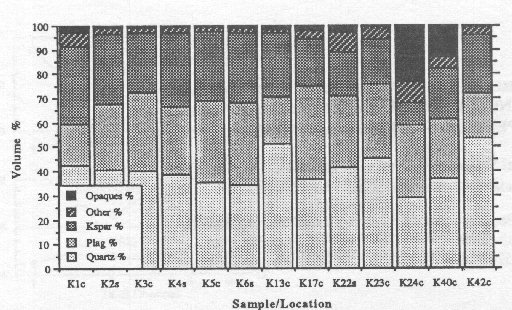
FIG. 1. Mineral percentages derived from point-counts of thirteen sand samples. Sample numbers represent the collection site with a 'c' or 's' extension indicating a dune crest or swale. Samples K1c through K6s were collected from the same color unit and analyzed to verify the accuracy of the point-counting technique (note the similarity of the percentages). Samples K13c through K42c were collected along a 9.5 km N-S traverse through the most active region of the dune field (note the variation when compared to the first six samples). Also significant is the low average quartz percentage (40.4%).
2. SAMPLE ANALYSES
Forty-eight bulk samples were collected along a 9.5 km N-S traverse. These samples represented different image color units as well as position on the dune (crest vs. swale). Thirteen of the forty-eight bulk samples were chosen for detailed analyses to determine modal abundances. Six of these were from a small, mineralogically similar
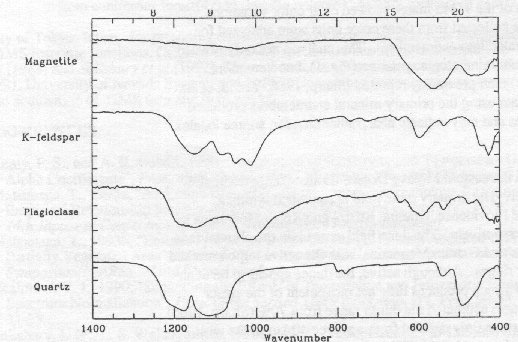
FIG. 2. Laboratory emission spectra of the four endmembers - quartz, plagioclase, K-feldspar and magnetite (Avg. grain diameter = 500 - 710 Ám). Minerals were separated from bulk samples using magnetic and heavy liquid separation techniques.
region and acted as a check on the consistency of the laboratory analysis. The bulk sand was split into 20 g samples (Cadle, 1955) from which thin sections and laboratory emission spectra were obtained (Christensen and Harrison, 1992). Over 200 grains per sample were counted to determine mineralogy and particle diameters (Jones, 1987). Samples K13c - K42c show clear mineralogic variations throughout the dune field (Fig. 1). These variations appear real based upon: (1) the color variations in the TIMS image; (2) the differences in the laboratory emission spectra; and (3) the similar point count results from samples K1c - K6s. Certain samples, collected from low-lying areas, contained appreciable amounts of clay. The clay component, separated from the sand using a Na-pyrophosphate dispersent, was analyzed by X-ray diffraction and found to be primarily montmorillonite. Finally, approximately 4 g of the dominant mineralogic components were separated using heavy liquid (Na polytungstate) and magnetic separation. While tedious, this separation insured the use of the correct endmembers for the dunes. Because the spectrum of plagioclase, for example, can vary dramatically as a function of An number, separation is preferred over the use of library spectra. The spectra of these endmember minerals (Fig. 2) were used as inputs into the unmixing algorithm for both the lab and image spectra.
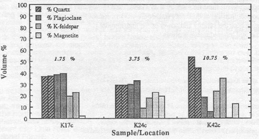
FIG. 3. Comparison of endmember percentages derived from point counts (first bar) and the unmixing model (second bar). The three samples show the best, average and worst case error.
3. KELSO DUNES IMAGE ANALYSIS
Thermal Infrared Multispectral Scanner (TIMS) data for the Kelso region of the Mojave Desert were acquired in September 7, 1984. Ground resolution at nadir was approximately 17 m/pixel. The original flight line extends north from the dunes to the southernmost Cima basalt flows (Barbera, 1989). The data were calibrated and geometrically corrected for the scan angle of the instrument. Atmospheric path radiance was removed using LOWTRAN7 with the standard midlatitude summer model. The calibrated radiance images were then converted to six emissivity and one brightness temperature image (Realmuto, 1990) using a maximum assumed emissivity of 0.973 (derived from the average of all laboratory spectra). The spectra of the mineralogic endmembers convolved with the TIMS filter functions resulted in 6-point spectra that were used as inputs into the unmixing model. Mineral percentage images show very high concentrations of feldspar within the dunes as well as on alluvial surfaces extending from the immediate mountain ranges. This relation, coupled with the lack of feldspar being introduced from the previously assumed western source, indicates this mineral is locally derived. By similar reasoning, the magnetite and other mafic minerals seem to be the direct result of weathering of amphibole rich metasediments in the Granite Mountains. While a certain percentage of the quartz within the dunes is likely derived locally, it appears, based on a higher concentration to the northwest, that some amount may come from the western source some 40 km away.
4. RESULTS
This study represents a rigorous attempt to quantify and validate the linear mixing assumption of thermal emission spectra for a real geologic surface. It also is one of the more detailed laboratory studies of the Kelso sand mineralogy. The sum of both provided an excellent validation of mineralogic retrieval algorithms to remotely acquired data. Model-derived endmembers percentages agree to within an average of 5.4% of the point count figures. The error range varied from 1.75% (K17c) to 10.75% (K42c) (Fig. 3). The general agreement between the petrographic and spectral analyses is dramatic considering the tims difference between image and sample collection, as well as the scale difference between image and lab samples. Applied to the TIMS data, the linear model reveals a much less mature dune mineralogy with a more local source for the sand than previously reported. Results of this study further the work of Ramsey and Christensen (1993) and indicate both the validity and power of the linear model especially when applied to thermal infrared image analysis.
5. REFERENCES
Barbera, P.W., 1989, Geology of the Kelso-Baker Region, Mojave Desert, California using thermal infrared multispectral scanner data, M.S. Thesis, Arizona State University, 198 p.Cadle, R.D., 1955, Particle Size Determination, Interscience Publishers, New York, N.Y., pp. 57.
Christensen, P.R. and S.T. Harrison, 1992, "Thermal-Infrared Emission Spectroscopy of Natural Surfaces: Application to Desert Varnish Coatings on Rocks", submitted to J. Geophys. Res.
Gillespie, A.R., M.O. Smith, J.B. Adams and S.C. Willis, 1990, "Spectral Mixture Analysis of Multispectral Thermal Infrared Images", in Abbott, E.A. (Ed.), Proc. of the Second TIMS Workshop, JPL Pub. 90-55, JPL, Pasadena, Calif., pp. 57- 74.
Jones, M.P., 1987, Applied Mineralogy: A Quantitative Approach, Graham and Trotman, Norwell, Mass., pp. 24, 74-75, 177.
Paisley, E.C.I., N. Lancaster, L.R. Gaddis, and R. Greeley, 1991, "Discrimination of Active and Inactive Sand from Remote Sensing: Kelso Dunes, Mojave Desert, California", Remote Sens. Environ., vol. 37, pp. 153-166.
Ramsey, M.S. and P.R. Christensen, 1992, "The Linear 'Un-mixing' of Laboratory Infrared Spectra: Implications for the Thermal Emission Spectrometer (TES) Experiment, Mars Observer", Lunar and Planet. Sci. XXIII, pp. 1127-1128.
Ramsey, M.S. and P.R. Christensen, 1993, "Ejecta Distribution at Meteor Crater, Arizona, Derived from Thermal Infrared Multispectral Scanner (TIMS) Data", to be submitted to J. Geophys. Res.
Realmuto, V.J., 1990, "Separating the Effects of Temperature and Emissivity: Emissivity Spectrum Normalization", in Abbott, E.A. (Ed.), Proc. of the Second TIMS Workshop, JPL Pub. 90-55, JPL, Pasadena, Calif., pp. 26-30.
Sharp, R.P., 1966, "Kelso Dunes, Mojave Desert, California", Geol. Soc. Am. Bull., vol. 77, pp. 1045-1074.
Yeend, W., J.C. Dohrenwend, R.S.U. Smith, R. Goldfarb, R.W. Simpson, Jr., and S.R. Munts, 1984, "Mineral Resources and Mineral Resource Potential of the Kelso Dunes Wilderness Study Area (CDCA-250), San Bernadino County, California", U.S. Geol. Survey, Open File Report 84-647, Washington D.C., 19 p.
------------------
Presented at: Fourth Annual JPL Airborne Geosciences Workshop (TIMS)
Date: 1993