"On the bank of Chartiers Creek...there lies a valley of unusual beauty. The creek
meanders in a graceful curve along its western bounds, and precipitous hills, rising on
the east, and stretching for a short distance to the north and south, at length change their
course at each extremity of the range, and slope gradually to the margin of the water."
History of Allegheny County, Pennsylvania, 1889
The name "Chartiers" is that of half-bred Indian, Pierre Chartiers, an Indian trader, who in 1743 came to the territory from Philadelphia and established a trading post on the stream now known as Chartiers Creek. The name was originally pronounced "Shirtee" in the Indian language, but gradually drifted to Chartiers. When Pierre Chartiers' mission as a French spy became known, he was obliged to leave the territory. The stream naturally took his name because his trading post was near the mouth of Chartiers Creek (Neighborhood History: Chartiers City, 1977).
A 1921 newspaper article, "Chartiers Ready to Join Forces With Pittsburgh," by Brownsfield Scott (1921), the author of The History of Allegheny County, 1753-1876 notes that, "no township in Allegheny County can boast a more interesting history than that of Chartiers. Its settlements were among the first, its prehistoric relics are the most wonderful, and its Indian adventures were among the most thrilling."
Among the historic buildings that were erected in the vicinity of Chartiers Creek in the middle of the18th century was the fort, or blockhouse, known then as the House of Refuge. It stood atop Crafton Heights. The House of Refuge was erected by early settlers for defense against hostile Indians who often visited the valley. Behind the walls of this Refuge, settlers would seek safety from Indian uprisings. It is believed that these uprisings were traceable to the displacement of Indians by the white man. Betsy Martin, in her book, The Story Of Crafton, notes that the name given to the Crafton/Ingram area by the Seneca Chief was Killemum. This area included a village, or camp, atop the east side of Chartiers Creek along Backbone Road. The Seneca tribe inhabited this area, and according to Martin, if they were not displaced by the white man, "the site would have provided a commanding view of wildlife in the valley or enemies approaching by footpath or canoe from the north, south or west."
In an effort to protect their hunting grounds from British settlers and speculators, the Indians sided with the French in 1754 as hostile outbreaks between the British and French ensued. The Indians despised the British because they believed the British wanted to displace all Indians in the territory. In 1755, the British ordered the erection of the first fort at the forks of the Ohio. This was an effort to protect their land interest. The French claimed this area and renamed it Fort Duquesne. A map of Fort Duquesne in 1754 is shown below in Figure 1.
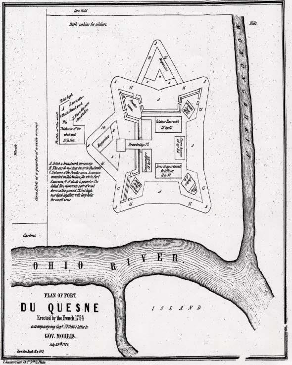
Map of Fort Duquesne in 1754
Figure 1
In 1758, the British, led by Scotsman General John Forbes reclaimed the area for the King and renamed it Fort Pitt for the English Prime Minister, William Pitt. In 1764 a 'peace agreement' was reached between the Indians and the British. It followed Colonel Bouquet's defeat of Pontiac at Bushy Run. Pontiac, was the Ottawa chief who had rallied the tribes in a desperate attempt to drive settlers back over the mountains (Martin). (See sketch of Col. Bouquet's engagement with Indians in Figure 2 below). As described in a program to commemorate the 150th anniversary of the battle of Bushy Run, the Indians stood firm in their attempt to protect their territory. The Ottawa chief
"...visited all the tribes of the six Nations and, in the absence of calendars or
the ability among Indians to reckon time as we do, he gave each of them a
bundle of rods from which they were to extract a rod every morning and,
when the last rod was drawn, they were to fall upon white settlers nearest them,
exterminate them and their families and besiege all intervening English Forts."
Fiftieth anniversary of the Battle of Bushy Run, 1913.
These instructions were often acted out and as a result, placed fear in the hearts of those who fought against the Indians. In Colonel Bouquet's first report from Bushy Run, he noted,
"In the morning the savages surrounded at the distance of 500 yards, and by
shouting and yelping, quite around that extensive circumference, thought to have
terrified us with their numbers...Tied to our convoy, we could not lose sight of it
without exposing it and our wounded to fall a prey to the savages, who pressed
upon us, on every side, and to move it was impracticable, having lost many
horses and most of the drivers stupefied by fear hid themselves in bushes."
Bouquet Papers from British Museum, Henry Bouquet, 1719-1765
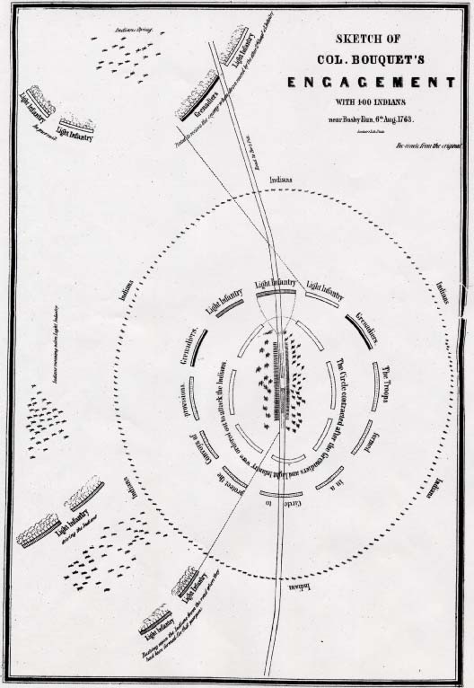
Colonel Bouquet's Engagement with Indians at Bushy Run
Figure 2
In 1790, the courts officially established Chartiers Township by using the southern part of Cecil Township. Subsequently, parts of Chartiers were divided to aid in the creation of Mount Pleasant and Canton (Forrest, 1926). It was not until 1921, that Chartiers Township was annexed to the City of Pittsburgh. At the time, the township included Chartier City, Windgap, Crafton Heights, Oakwood, East Carnegie and Boradhead Manor-Westgate village (Neighborhood History: Chartiers City, 1977).
For more information on the history of Chartiers Township, please visit the following site:
http://trfn.clpgh.org/cnc/crafton.htm
The following dates and events illustrate
the history of Chartiers Township:
1749: Celeron de Blainville, the first white man to record his impressions of the area, declares Chartiers Creek "the most beautiful he has seen on the Ohio River."
1752: George Washington and guide, Christopher Gist, toured the area
1763: Proclamation Line of 1763 put in place to declare settlement of lands to the south and west of the forks illegal
1768: Robinson township's first settler, James Bell tours Chartiers Creek after his release from Indians. John Bell (James Bell's brother), Chartiers first white pioneer reached what is now East Carnegie. Treaty of Fort Stanwix allows purchase of land from the Penns, who at the time claimed the region
1772: Andrew Swearingen, one of Washington County's most noted Indian fighters settled in Chartiers City
1773: Col. James Patterson came from Cecil County, Maryland and settled in Chartiers City
1777: John Hand records first case of Smallpox
1782: Will's Hollow, first schoolhouse to be erected in Chartiers Township
1800: Coal was first discovered on the land of James Allison. Col. Henry Noble used Chartiers creek as a point for shipping flour to New Orleans
1801: Four log schoolhouses constructed in Chartiers Township
1804: Andrew Robinson settled one half-mile northwest of Chartiers City
1808: Congress declared Chartiers Creek a navigable and public highway
1820: Population was 1330
1823: Obey House constructed by John Obey
1825: General Edward Hand, commander of Fort Pitt built a two-story log hospital for convalescing soldiers
1828: "Fall Hole" in Chartiers Creek was used to power the areas first woolen mill
1829: First church (Roman Catholic) to be constructed in the area
1830: Population was 1575
1840: Population was 1616
1851: Chartiers Township was erected by act of the Pennsylvania assembly
1863: Boundary line between Chartiers and Canton was changed and adjusted to present location
1865: First post office established
1871: The Chartiers branch of the Pennsylvania Railroad was completed
1872: John Doolittle incorporates Chartiers Borough from Robinson Township
1883: The first coal mine on the Chartiers railroad opens
1886: A total of seven schools were erected
1890: Creamery constructed by J.K. Stevenson
1900: Hallam Brothers, of Washington, purchase Ewing farm and opened coal mine
Population was 2000
1925: Midland mine purchased by Pittsburgh Coal Company
1972: Chartiers Valley nicknamed "Flood Valley" due to ravaging floods
1973: Multi-million dollar dredging project proposed to lessen floods
1990: Population was 7,603